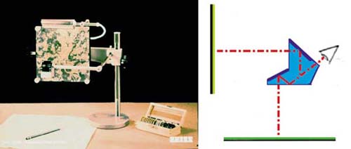
the glossy Zeiss camera, which can be used for map updating. As you can guess from the diagram, the observer, looking through a prism, sees the photographic image (arranged on the vertical plane) and the graphic image (arranged on the horizontal plane) on which he can draw superimposed. To update a cartography, simply place a recent photograph on the vertical plane of the same area represented in the cartography. By appropriately varying the enlargement of the photograph, it is possible to superimpose it on the graph and, therefore, add any missing information.