Using the
satellite image in cadastre
STAGE OF WORK
- General
considerations.
In Romania during the
communism, the propriety was taking by the state. The land of the landowners
was taking by the state. About 15 years, the new governments try to return the
proprieties to old owners. It is a very difficult work because there are many
interests. For to accomplish the task, in every locality was establish a
commission for return the land to old owners. Technical, for every locality
must be restoring the old map. But, the old map not exists for the south and
west of the country (Valachia and Moldavia). Only in Transylvania exist the old
maps of the Territorial Book. So, in this way, for the most part of the
Romanian territory must be made the parcelling map. This map is the base for
the title of propriety. According the Romanian law, every owner must sign the
drawing of every parcel, corresponding dimensions and neighbour (name and title
of propriety). The surface must be in tolerance, according with the act. The
intent of our work is to use the satellite image for the new cadastre map. With
this methodology we must respect the precision of ± 20 cm for every point
measured or vectorised.
- The iscarry of
the work.
2.1
Preparing.
Romania is dividing in 42 departments. In every
department exists an Office of Cadastre. The Office gives us the next
documents:
-
existing
maps with the locality limits;
-
existing
maps for the intravilan and the names of the villages;
-
existing
maps of the new parcels (if exists!);
-
title
and maps of the economical enterprise (private or state owners);
-
geodetic
network;
-
existing
cadastral maps;
-
name
and other data about every owner.
2.2
Field recognize.
It was recognize
all the geodetic points and the administrative limits of the locality. We recognize
in the field the state big properties. We detain the topographical plan at
1:5000 and we try to restore the contour of the old proprieties according with
the satellite image.
2.3
Realization of the digital model of the terrain for the relief correction
of the satellite image.
We digitise the
level curvature on the plans at 1:5000 for realize the 3D terrain model. The
precision is enough for this purpose.
2.4
Performed measuring.
The geodetic
network accomplishes the accuracy necessary for the work, respectively under ± 5 centimetres. It was
determinate around 20 mark points for scaled the satellite image.
We consider the
accuracy of the detail points must be batter in intravilan. For this reason
every propriety from intravilan was determinate by direct measuring with total
stations. The general accuracy was less than ± 10 centimetres for each
point. At the constructions, we use the roulette for the inaccessible points.
In extravilan was
determinate by direct measuring using total stations or GPS receivers only the
points for describe the roads, the irrigation canal, railway axis, some parcels
limits. For the extravilan we consider it is sufficient the satellite image,
combine with some direct measurements and the parcel plans. The general
accuracy for a point in extravilan was about ± 20 centimetres.
2.5
Study works.
2.5.1
Geodetic network adjustment.
It was realise by
last square method, indirect measurements, with equations for distances,
directions and GPS coordinate. The adjustment was realising in block for the
three types of measurements. The precision obtained was in requirements of the
National Office of Cadastre. The adjustment was realising using the weight for
each measurement.
2.5.2
The computing of the details point.
The computing was
realising with respect for national projection: Stereografic 1970. Some points
were verified by double measurements. Another verifies was made by the image.
2.5.3
Made the objects (surfaces).
We use the terrain
drawing made by an employer. Every object was construct in the computer using
AUTOCAD program. The GIS used is MAPSYS (Romanian program) and is compatible
with AUTOCAD MAP.
We positioning the
proprieties received from the Cadastre Office or from the local administration,
in coordinate. If are realise in local system of coordinate, we integrate the
propriety in the new map. We close every propriety on his limits taken from the
local administration.
We transfer people
from our society and logistics to the local administration for collaborate in
the identification between the parcel and the owners.
2.5.4
Settlement of the locality limits.
It was constitute a
commission from local administration for represented the locality in according
with the neighbours. Identical, every neighbour constitutes a commission too
for visit and fixed the limits.
2.5.5
Stable the limits of every cadastral sector. Cadastral number.
According the
existing normative, we define the limits for every cadastral sector. The roads,
the railways, the canals are himself cadastral sectors. The intravilan is a
cadastral sector too.
In every locality
already exist cadastral numbers. These numbers are replacing by the new
numbers.
- Settlements of
the juridical form for finish the proprieties law, according with the cat
aster law (Law 7/1996).
According with the
law of cat aster and immovable publicity, article 2, „The general cat aster is
organise at the territorial administrative level: commune, town, department and
for all the country”. According article 11c, the general cadastre suppose:
„identification of the immovable based on proprieties acts, or if it is
missing, based on the possession exerted under owner name; the measuring of
alls terrain parcels included in a territorial administration...”. According
with article 12, paragraph 2: „The owners of immovable are oblige to permit the
access of the specialists for execute the cadastral works.....”.
After finish the
plans and the file, every owner come to the city hall and confirm the dates for
to inscribe the title on the territorial book registration. According to the
same law, „The litigations about the exacting dates could be presented by the
owners, official, in term of 60 days from the communications, to the Cadastre
Office”.
On the territorial
book registration we will present an ensemble plan of the locality, with the
cadastral sectors. Every cadastral sector will be realise on leafs, 1:500
scale. On every cadastral sector will be presented every parcel with his
characteristics: cadastral number, post number. Every propriety has an file.
Cadastral sectors belonging to the Romanian state will be registrant
separately. In this way, every parcel will be unique, with a definite number.
Will be annexed the
parcel register, owners register, etc.
- Realize of the
Geographic Information System.
We used the MAPSYS
program, created by a Romanian informatician, 5.3 versions. This program
contain facilities for realise an efficiency using of the fields. In this way,
for the local administration will be accessible the next dates:
- parcel owner;
- parcel surface;
- act of propriety;
- land cultivation;
- dates about
constructions;
- taxes obviousness;
- dates about
populations;
- agricol census.
In this application it is
possible to complete with another information necessary for land
administration.
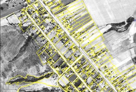
intravilan example
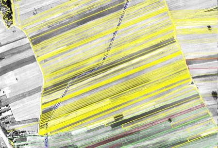
extravilan example